3
SHIER RINGS ROADWAY CORRIDOR CHARACTER STUDY
The City of Dublin began an inventory
of important roadway corridors 2009
to review land use, roadway design,
and roadside character. Each roadway
corridor faces unique challenges in terms
of transitioning land use character, aging
infrastructure, and development pressures.
The first of these planning efforts was the
Hyland Croy Roadway Character Study,
completed in June 2011.
The next area for examination is Shier Rings
Road. This roadway contains a unique mix
of industrial, office, residential, and City
facilities, along with vacant land and infill
sites. Nearly all of the area is coveredby new
planning efforts and zoning regulations
under the Shier Rings TechFlex District and
the West Innovation District.
At the same time, the City identified various
business districts, principally located in the
central core of the city (see Map 6). The
business districts are designed to promote
clusters of similar types of businesses and
industries, allowing each area to benefit
from appropriate access, visibility, and
proximity to support uses and services.
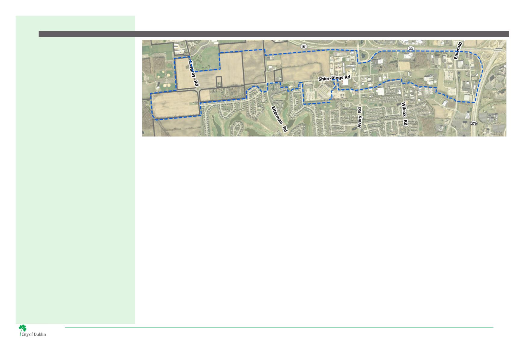
MAP 2 | SHIER RINGS ROAD CORRIDOR STUDY AREA
The Shier Rings Roadway Corridor Character Study area
is bounded by US Highway 33 to the north, I-270 to the
east, Cosgray Road to the west (including parcels just
west of Cosgray), and properties along the south side of
Shier Rings Road.
Strategically located at the juncture of US 33 and
I-270, Dublin is home to over 41,000 residents, more
than 3,000 businesses, and hosts an estimated 65,000
jobs in administration, technology, science, health and
information. Dublin’s primary employment core along
I-270 and US 33 is home to major corporations and
technology-based firms. This area has been divided into
seven business districts.
The Shier Rings Road Technology Flex District is
one of the city’s key business districts. The area is
predominately comprised of light industrial uses and
forms a physical connection between the Emerald
Corporate District ringing I-270 and the growing West
Innovation District. Shier Rings Road provides a direct
east-west connection between these two districts, while
providing access to single-family neighborhoods to the
south. Large undeveloped parcels within the study area
provide important opportunities for new businesses
and/or expansions of existing Dublin businesses.
Future development will need to transition between
existing development and the contemporary, high-tech
development that will characterize the West Innovation
District.
A considerable amount of planning has taken place for
the far west end of the Shier Rings Road corridor west
of Avery Road as part of the West Innovation District
planning efforts, and portions of Shier Rings Road along
Avery Road have been studied as part of the Avery Road
Corridor Special Area Plan within the Dublin Community
Plan. Because Shier Rings Road has never been examined
in its entirety, this project will serve as an amendment to
the Dublin Community Plan through the comprehensive
study of this roadway.
The purpose of this study is to provide detailed policy
and general design guidance for future roadway
improvements and surrounding land use character
in this important corridor. This study builds on the
extensive planning studies completed for portions of
the study area, including the Dublin Community Plan for
land use and transportation network recommendations,
which will guide future improvements to the design and
character of Shier Rings Road.
It is important to note that none of the improvements
are imminent; this study is in anticipation of future
roadway projects, consistent with Dublin’s tradition of
planning for future infrastructure improvements.
BACKGROUND
PROJECT PURPOSE
STUDY AREA OVERVIEW
PLANNING GOALS
1. Analyze existing conditions and previous planning
efforts, including the Dublin Community Plan Special
Area Plans, Future Land Use Map, and Thoroughfare
Plan.
2. Provide strategies for integrating and balancing
transportation mobility planning with land use and
development character objectives identified in the
Dublin Community Plan.
3. Recommend right-of-way improvements to best
support the future land use mix and community
character objectives while maintaining safe and
efficient transportation.
4. Provide recommendations for pedestrian and
bicycle facilities, as well as landscaping, lighting,
and furnishings to enhance the visual appeal of the
corridor.
Introduction


