13
SHIER RINGS ROADWAY CORRIDOR CHARACTER STUDY
Existing Corridor Character | Analysis
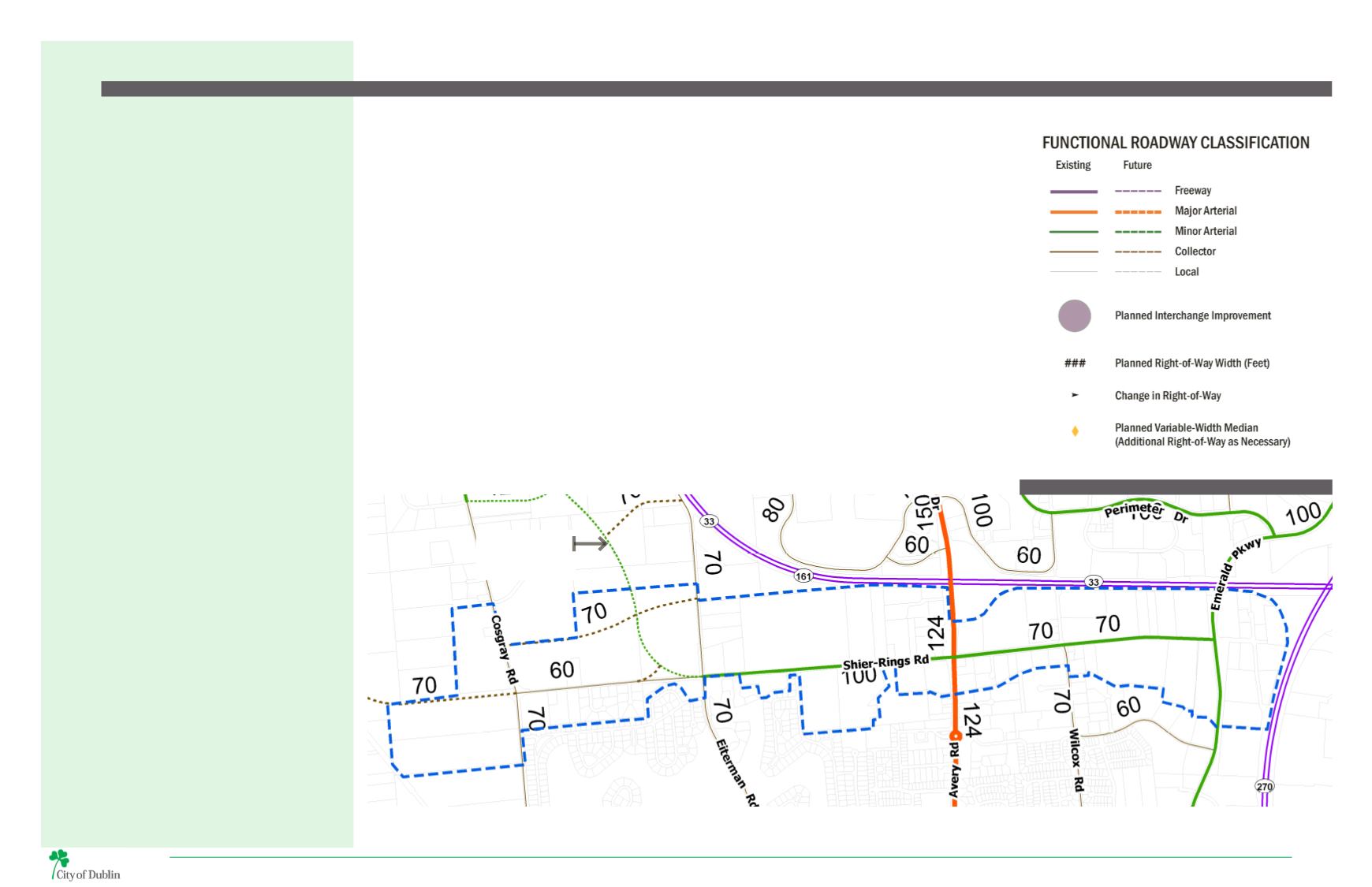
THOROUGHFARE PLAN
The Thoroughfare Plan, adopted by City Council as a
component of the Dublin Community Plan, is composed
of two elements:
1. A map showing existing and planned roads by
functional classification and right-of-way width; and
2. A table that describes each roadway and its planned
improvements, including number of travel lanes.
The roadway network shown in the Thoroughfare
Plan map identifies the number of lanes needed to
accommodate year 2035 development in Dublin.
The
Thoroughfare
Plan
includes
several
recommendations for the Shier Rings Roadway Corridor
that will require improvements and changes from
today’s existing conditions. The most significant change
includes the realignment of Shier Rings Road north into
theWest Innovation District, just west of the intersection
withEitermanRoad. Inconjunctionwith the realignment,
Shier Rings Road is recommended to be widened from
two lanes to four, with a center median and turn lanes
to accommodate increased vehicular traffic resulting
from new development in the West Innovation District.
Accordingly, Shier Rings Road west of the realignment
to Cosgray Road will be ed-emphasized to maintain the
existing residential character, although Darree Fields
Park will remain a destination for those traveling on
Shier Rings Road.
Over the long term, the Thoroughfare Plan shows an
extension of Shier Rings Road west of Cosgray Road. As
development increases in the West Innovation District
area, additional connections through the city may be
warranted, and direct access from Shier Rings Road to
Houchard Road may be necessary. The timeline for this
expansion will depend on development pressure and
traffic demand, which the City continuously monitors.
Final alignments and ROW widths will be determined
through the planning & enginnering studies for the
throughfare plan, business districts and area plans.
ROADWAY CLASSIFICATIONS
Major Arterials
Major arterials serve the major activity
centers, the highest traffic volume
corridors. This type of facility provides
service for significant intra-area travel
(such as between central business districts
and outlying residential areas), travel
between major inner-city communities,
and commutes between major suburban
centers. Frequently, the major arterial
system carries bus routes. Service to
abutting land is subordinate to travel
service.
Minor Arterials
Minor arterials interconnect with and
augment the major arterial system. This
type of facility will accommodate trips of
moderate length at a somewhat lower level
of mobility thanmajor arterials. This system
places more emphasis on land access and
may carry local bus routes, but ideally does
not penetrate identifiable neighborhoods.
Collector Streets
Collector streets provide both access to
property and traffic circulation within
residential neighborhoods and commercial
or industrial areas. This system collects
traffic from local streets, accessing the
residential neighborhoods, and disperses
it to the arterial system. The collector street
system may also carry local bus routes.
Local Streets
Local streets comprise all facilities not
found in one of the higher systems.
These primarily facilitate direct access to
abutting land and connect to the higher
order systems. They offer the lowest
level of mobility and usually contain no
commuter bus routes. Service to through-
traffic movement usually is deliberately
discouraged.
MAP 8 | THOROUGHFARE PLAN
SHIER RINGS
REALIGNMENT


