9
SHIER RINGS ROADWAY CORRIDOR CHARACTER STUDY
SPECIAL AREA PLANS
In those areas of the City where substantial
development and redevelopment activity
is likely, special area plans provide a
framework to guide development in a way
that fosters a sense of place and establishes
community identity.
The plans provide graphic representations
of potential development areas and may
include illustrative configurations for new
streets, buildings, parking, open space
and circulation. They are accompanied
by descriptive text that explains existing
site characteristics, planning challenges,
design considerations, and planning goals.
These plans are to be used as a guide for
site planning concepts, and should not
be interpreted or applied literally. The
actual mix of land uses, locations and
configurations of buildings, parking areas,
thoroughfares and access points will
be determined on a case-by-case basis
through development impact studies and
the development review process.
In some cases, existing land uses and
structures are not included in the future
land use concepts. However, existing uses
and underlying zoning will continue to be
respected for all properties. In the event
that circumstances change in the future,
these plans are intended to provide clear
direction to City staff and decision-makers
so that development and redevelopment
may occur in a well-planned and cohesive
manner.
The level of detail provided for each special
planning area depends on a number of
factors, including: its location within the
City’s overall land use planning area and
its relationship to other areas of the City;
its geographic scale and existing land
ownership patterns; the degree to which
the area is already developed and/or is
expected to redevelop; and the complexity
of planning, transportation, or economic
development issues relevant to the area.
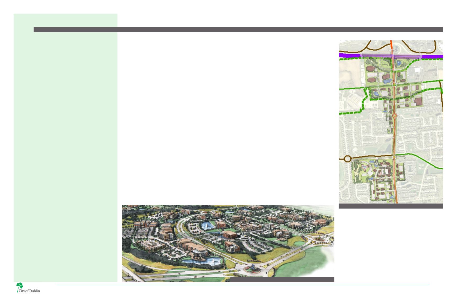
AVERY ROAD AREA PLAN
The Avery Road corridor stretches from the U.S. 33
interchange at Avery-MuirfieldDrive toDublin’s southern
boundary, providing a connection from community-
scale retail areas north of U.S. 33 to Columbus and
Hilliard to the south. The area includes an assortment of
residential and light industrial structures annexed into
the city during the 1990s and rezoned in 2011 to the
Innovation District and Technology Flex zoning districts.
As a major north-south route transportation issues
define the Avery Road corridor. Landscape treatments
and roadway design, in conjunction with road widening
projects, will provide a cohesive visual character for
the corridor. Necessary right-of-way expansions to
accommodate these improvements will continue to
generate land use and access management challenges
with respect to existing residential and commercial
properties.
Future interchange improvements at U.S. 33 will have
a significant impact on industrial uses near Shier
Rings Road; however, the timing and design of these
improvements is uncertain. Establishing gateways for
the West Innovation District and Shier Rings TechFlex
District, encouraging appropriate technology-based
office and industrial research uses, and retrofitting
existing industrial uses to better fit with the overall
context of the area will be important.
The northern half of the Avery Road Area Plan, centered
around the intersection of Shier Rings Road and Avery
Road, is directly related to the Shier Rings Roadway
Corridor Character Study. The need to address access
and transportation challenges and establish a gateway
at this prominent intersection, remain key issues.
WEST INNOVATION DISTRICT AREA PLAN
TheWest Innovation District is a business neighborhood
identified as a critical component of Dublin’s business
core. Located at thewest end of the SR 161 corridor along
U.S. 33, the West Innovation District is Dublin’s targeted
area for future technology-related development. The
district includes over 1,100 acres of largely undeveloped
land that provides opportunity for future growth
anchored by the new Ohio University Dublin Campus,
which opened in 2014. Key elements include:
• Defined future development patterns and character;
• Programmed future infrastructure extensions; and
• A framework plan for development-ready zoning.
The West Innovation District Area Plan was developed
through public input spanning many years. In 2011,
City Council adopted the Economic Advancement Zone
(EAZ) Plan. Following the adoption of the EAZ Plan,
City Council adopted new zoning regulations designed
to implement critical elements of the plan related to
land use, development character, and landscaping. As
part of the 2013 Community Plan amendment, the EAZ
plan was integrated into the Community Plan, and was
renamed as the West Innovation District Plan. In the fall
of 2015, the City of Dublin initiated another planning
study for the West Innovation District to align with Ohio
University’s campus master planning, which is running
concurrently, and to better reflect current market and
development conditions. This study is expected to be
completed by the end of 2016, with implementation of
recommendations expected in early 2017.
The Shier Rings Roadway Corridor runs through the
southernmost portion of the West Innovation District
planning area.
Corridor Character | Policy
MAP 4 | WEST INNOVATION DISTRICT
MAP 5 | AVERY ROAD AREA PLAN
AVERY ROAD
SHIER RINGS ROAD
US 33


