The Ever-evolving Infrastructure Network that Transformed the City of Dublin
“From the beginning, Dublin sparkled with gems such as green fertile fields, clean springs, glistening streams and lush forests. The warm inland sea that once covered the area deposited rich layers of limestone, another natural resource that would enhance early economic development. Completing the rustic landscape was a river with tributaries that would provide local transportation and access to faraway destinations.” – “Dublin’s Journey” – the City of Dublin’s history book
The evolution of Dublin from a quiet village along the Scioto River into one of Central Ohio’s most dynamic suburban communities is, in many ways, a story written in asphalt, concrete and carefully planned connectivity. Over the past five decades, a series of deliberate transportation decisions – ranging from regional highway investments to finely tuned local street networks – have not only accommodated growth but actively shaped it. Today, Dublin stands as a clear example of how infrastructure, when aligned with long-term vision, can transform a community’s identity, economy and form.
Dublin’s modern growth trajectory began in earnest in the 1970s with the construction of Interstate 270. Prior to this, Dublin functioned primarily as a rural farming village with limited regional access. The completion of the outer belt fundamentally altered that dynamic, placing Dublin at a strategic crossroads within the Columbus metropolitan area. Suddenly, the community was no longer isolated – it was connected. This accessibility catalyzed residential and commercial development, enabling Dublin to grow rapidly through the 1980s and beyond.
Yet, while I-270 provided the regional framework, it was Dublin’s local roadway decisions that translated access into place-making. The development of Muirfield Village and its associated road network, including Muirfield Drive, exemplified this approach. This model not only accommodated significant residential growth but also set a precedent for high-quality, master-planned developments that would become synonymous with the City. In doing so, it also strengthened Dublin’s commitment to connectivity and quality of life, as an extensive network of recreational paths encouraged walking, biking and other alternative modes of transportation throughout the neighborhood.
As growth accelerated, Dublin recognized that relying on a handful of arterial roads would eventually constrain mobility and limit economic potential. In response, the City pursued the construction of Emerald Parkway – a transformative north-south corridor paralleling I-270. Initiated in the 1990s, Emerald Parkway was more than a road; it was a strategic investment in capacity and land use. By opening up large swaths of previously inaccessible land, the corridor enabled significant commercial development, including millions of square feet of office space.
Equally important was Dublin’s decision to relocate and modernize Riverside Drive. Historically aligned along the Scioto River, a portion of Riverside Drive was shifted east to create space for Riverside Crossing Park, improve safety and better integrate with emerging development patterns. This move reflects a broader philosophy that has guided Dublin’s transportation planning: infrastructure should not simply respond to growth – it should anticipate and direct it. The realignment of Riverside Drive helped create a more coherent corridor, supporting both vehicular movement and multimodal access, including new shared-use paths and pedestrian connections.
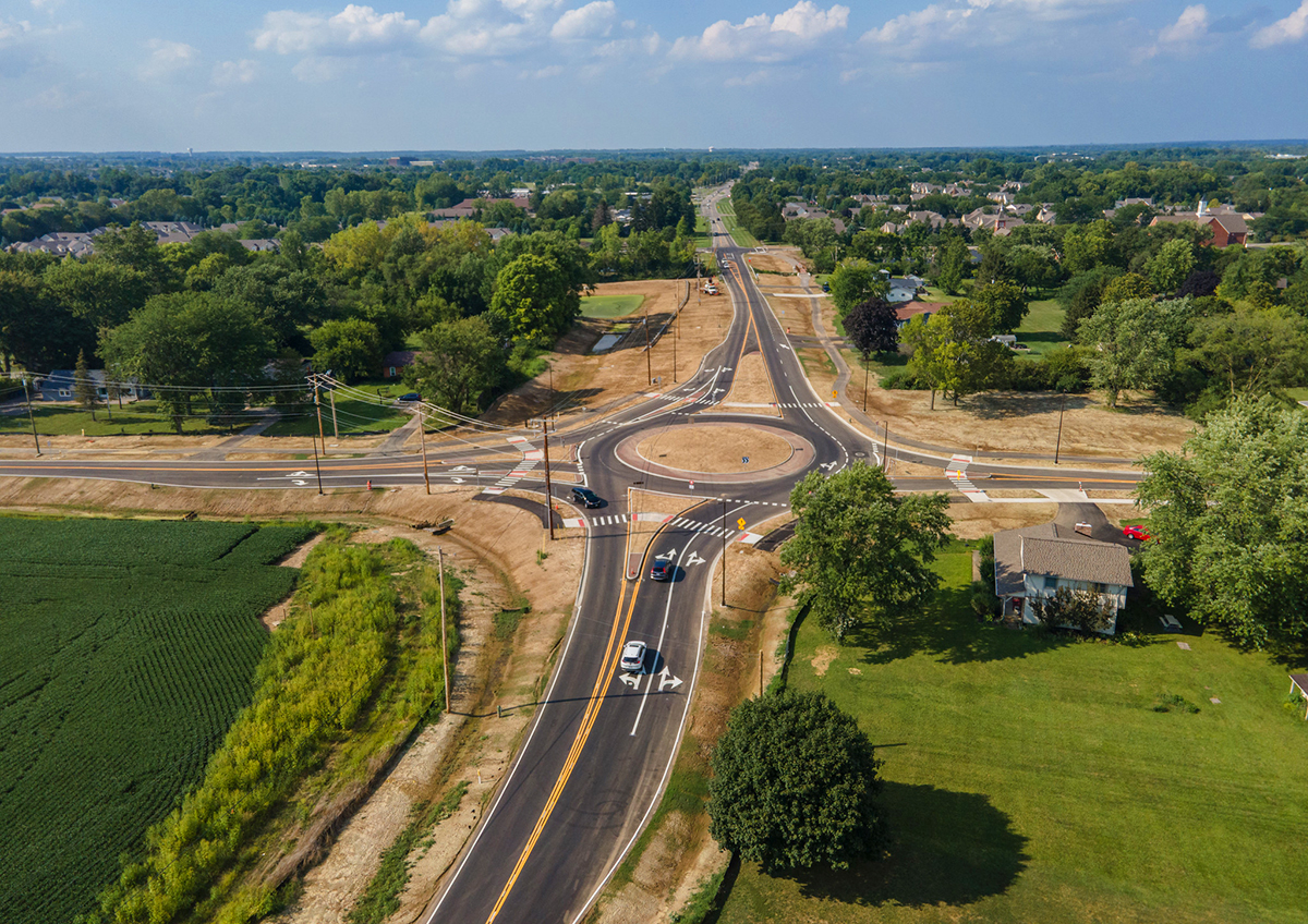
A defining feature of Dublin’s transportation strategy has been its holistic, systems-based approach to network development. Rather than relying on a limited number of major corridors, the City has intentionally built a connected network of roadways designed to distribute traffic across multiple routes. By thoughtfully managing the scale and character of its roadways, Dublin has encouraged travel to disperse across the system, reducing routine reliance on any single corridor. This network-based philosophy emphasizes connectivity, redundancy and flexibility, ensuring that residents and visitors have a range of travel options. Reflected in the City’s Multimodal Thoroughfare Plan, this approach has been implemented incrementally through roadway extensions, intersection improvements, and strategic connections between neighborhoods, commercial areas and employment centers.
Nowhere is this approach more visible than in the Bridge Street District. Once dominated by auto-oriented commercial development, this area has been reimagined through the intentional creation of a walkable urban grid. Streets have been reconfigured and extended to form smaller blocks, enabling a mix of uses and improving pedestrian accessibility. The district’s success, anchored by mixed-use development, public spaces and multimodal infrastructure, demonstrates how transportation design can directly influence urban form and economic vitality.
Complementing the street grid is the Dublin Link, a signature pedestrian bridge connecting the historic west side of the river with the newer Bridge Park area to the east. Completed in 2020, the bridge symbolizes Dublin’s shift toward a more balanced transportation system — one that prioritizes not only cars but also people. By physically linking two distinct parts of the City, the bridge has reinforced the idea that connectivity is not just about movement, but about creating a unified community.
In parallel with these local initiatives, Dublin has continued to invest in regional connectivity through interchange upgrades and corridor improvements. Enhancements to the I-270 and U.S. 33 interchanges and surrounding roadways have been critical in managing traffic volumes while maintaining access to key employment and commercial areas. At the same time, the City is actively exploring opportunities to expand its transportation network westward to serve the West Innovation District, unlocking hundreds of acres for new and exciting development. As these connections are planned, Dublin remains committed to its vision of creating roadways that safely and comfortably accommodate all users, including those walking and rolling, ensuring that future growth is both accessible and inclusive.
Looking ahead, Dublin’s transportation vision remains forward-thinking and adaptive. Projects such as the Emerald Connector, a proposed new crossing over I-270, illustrate the City’s continued commitment to expanding its network and addressing emerging challenges. By improving connectivity between key corridors, reducing congestion on overburdened routes like Sawmill Road, and incorporating pedestrian and bicycle infrastructure, the project aims to enhance both mobility and quality of life. Concurrently, Dublin is planning a future passenger rail station and mobility hub, positioning the community to better connect to regional transit opportunities and beyond. The City is also looking toward emerging technologies, including vertiports – a dedicated takeoff and landing area for electric vertical aircraft – and other innovative mobility solutions, to ensure its infrastructure can adapt to the rapidly evolving transportation landscape in the years ahead.
More broadly, Dublin is increasingly focused on multimodal transportation, recognizing that the future of mobility extends beyond traditional roadway expansion. Investments in shared use paths and pedestrian infrastructure are complemented by a growing emphasis on smart mobility solutions. The City is actively partnering with emerging technology companies that are reshaping how transportation systems operate – from real-time, demand-responsive signal operations to advancements in electric and autonomous vehicles, as well as vehicle-to-infrastructure and vehicle-to-vehicle communications.
These innovations not only improve safety, reduce congestion and enhance overall system efficiency without the need for significant physical expansion, but also elevate the everyday travel experience for residents and visitors alike. In an era where land is increasingly scarce and costly, Dublin recognizes that optimizing the performance of its existing roadway network is not only practical, but essential.
The transformation of Dublin is a testament to the power of intentional planning and strategic investment. From the catalytic impact of I-270 to the finely grained connectivity of the Bridge Street grid, each transportation decision has played a role in shaping the City’s growth and identity.
As Dublin looks to the future, its challenge will not simply be to build more roads, but to continue building the right ones, connections that enhance mobility, support economic development and reinforce the sense of place that has made the City a model for others to follow.